
Internet of Things and condition monitoring
Tower status monitoring system
With the development of communication and electric power, a large number of iron towers have appeared in cities and villages for the construction of mobile communication base stations and electric towers. These towers are high-rise buildings, with the passage of time and the impact of the environment, there will be tilting, swaying, even collapse and other accidents, further cause casualties and traffic interruption and other major accidents.
The company proposes a remote real-time condition monitoring system based on multi-sensor and wireless communication network.
The system through the tilt sensor, temperature sensor, wind speed and direction sensor, infrared intrusion sensor, camera, IC card reader and other equipment, sense the tower tilt, settlement, temperature, wind and real-time video, sent to the remote server through wireless communication network, calculate the health status of the tower. Use the desktop monitoring terminal or mobile phone client to monitor for illegal intruders or other dangerous situations. Based on GIS geographic information system, it can effectively monitor, maintain and manage the health status of tens of thousands of towers in an area.

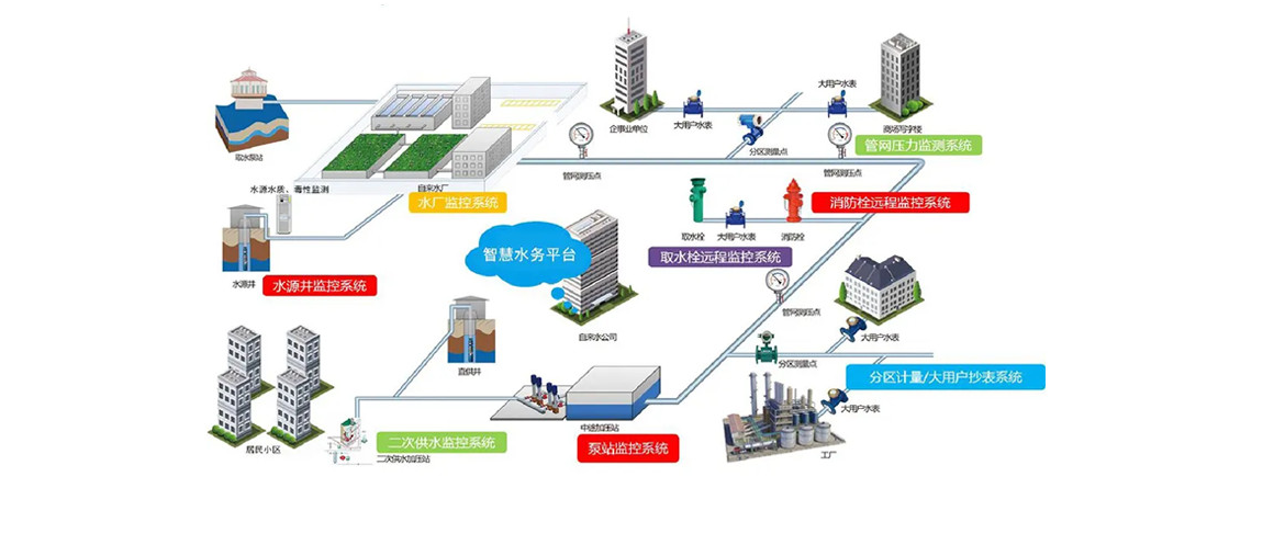
Urban water supply monitoring system
Urban water supply system is the basic lifeblood of a city, from water production to pipe network water supply, all need to be reliable and stable, without the slightest mistake.
The urban water supply monitoring system can carry out sensor detection and feedback control on the process of water plant, detect the key process parameters such as inlet and outlet water pressure, flow rate, residual chlorine and turbidity, and feedback control on the amount of chlorine and alum, the shutdown and power of water pump.
For urban water supply pipe network, the key data such as pressure, flow rate and residual chlorine can be monitored through pressure measuring point RTU.
Both the parameters inside the water, and the process parameters of the pipe network pressure, can be through a dedicated or public mobile communication network, the wireless communication network and private network cable, transferred to the city's unified central dispatching room, from the central dispatching room can realize the city water system and water supply situation of the comprehensive monitoring and scheduling control.
GPS Power line inspection system
Such a power patrol system based on GPS has changed the traditional mode of manual patrol, will greatly improve the efficiency and quality of power patrol, contribute to the safe operation of power system.

The power sector has a large number of field lines and towers, which need frequent maintenance to ensure the safe and reliable operation of the power system. Manual line inspection can not meet the needs of power operation.
The application of GPS technology can make the line patrol personnel automatically obtain the current position, through the comparison with the line geographic information system, automatically know the current tower identification number, at the same time, through the fast and effective software interface operation, accurate and standardized record tower inspection results. At the same time, the terminal handheld device held by the inspection personnel maintains effective real-time data communication with the central background server, and the inspection results can be quickly sent back to the central server for effective analysis and processing.
This kind of power line inspection system based on GPS changes the traditional manual inspection mode, greatly improves the efficiency and quality of power line inspection, and contributes to the safe operation of power system.
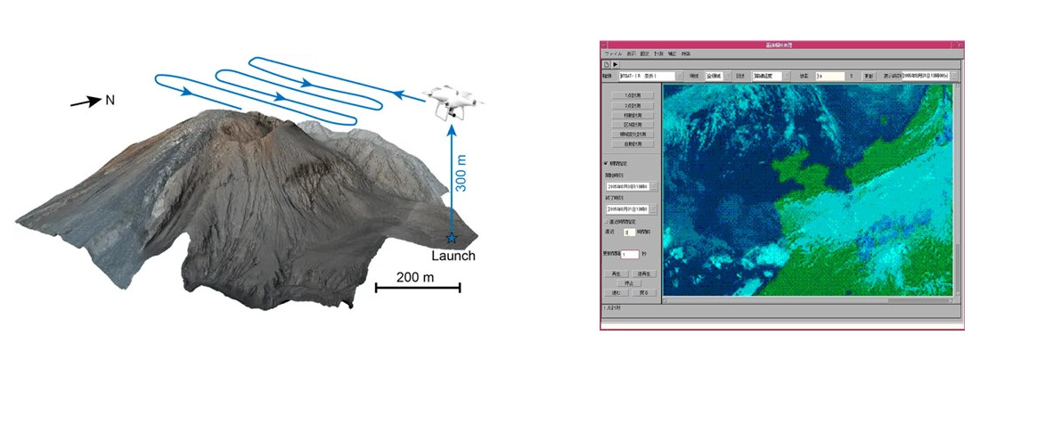
Airline Volcanic ash monitoring and information service system
The eruption of volcanic ash is so powerful that it creates a corrosive ash cloud in the air over a long period of time. Once it gets into the air lanes, it can seriously affect passing aircraft and even cause crashes. Therefore needs to be monitored by satellite images of volcanic eruption, volcanic eruption when the local meteorological data, over a period of time in the future projections on ash rose, diffusion and drift, affect the route, the data to the airlines, so airlines in a timely manner to take emergency measures.
Internationally, the Volcanic Ash Advisory Centre (VAAC) is responsible for providing information on the spatial distribution and predicted movement of volcanic ash in the atmosphere after volcanic eruption to weather observation stations, regional control centres, flight Information centres, WORLD Regional Forecast Centres and international flight Weather Information databases. There are nine VAAC centers around the world that monitor all regions of the world. our company was entrusted by Tokyo VAAC to develop the route volcanic ash information supply system within the jurisdiction of Tokyo VAAC, which has played a positive role in the practical application and has been well received by customers and made a contribution to aviation safety.
The problem